1 p.m. UPDATE: A winter storm continued to impact Western North Carolina on Saturday afternoon, with the National Weather Service maintaining multiple weather alerts and reporting significant snowfall across the region.
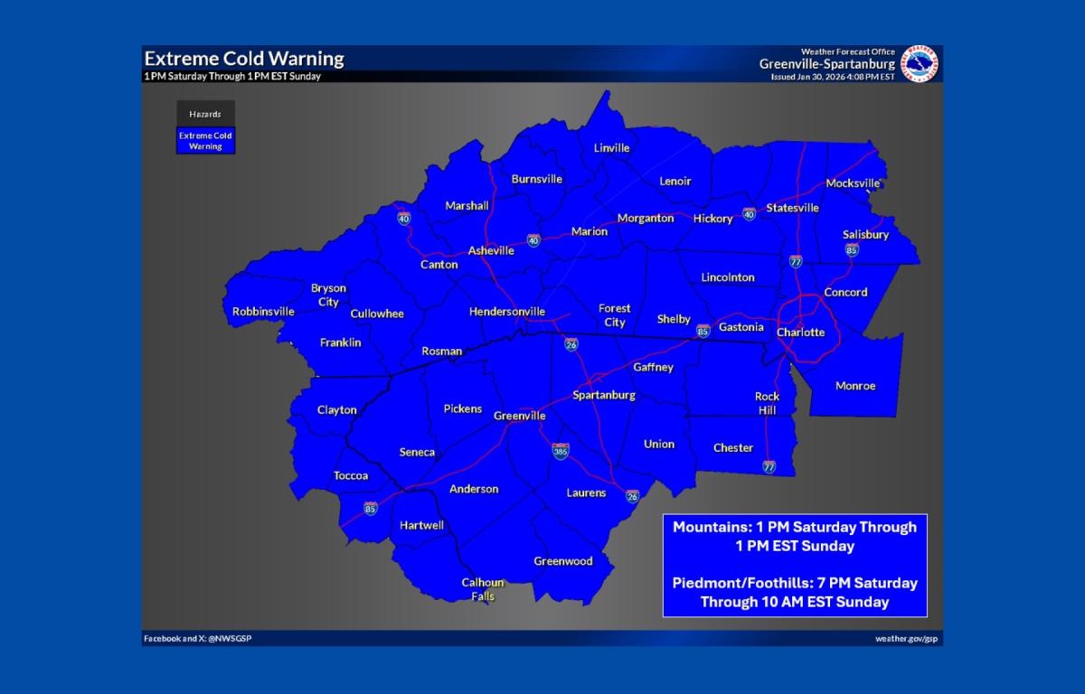
A Winter Storm Warning remains in effect until 7 a.m. Sunday, while an Extreme Cold Warning is in place through 1 p.m. Sunday, according to the National Weather Service office in Greenville-Spartanburg, South Carolina. A Wind Advisory is also in effect from 7 p.m. Saturday until 1 p.m. Sunday.
Snowfall totals reported by the National Weather Service through noon Saturday showed widespread accumulations across mountain communities. Sylva recorded 9 inches of snow, while Marshall received 8.5 inches. Hendersonville and Candler each reported 7 inches, and Clyde measured 8 inches.
Other reported totals included 6 inches in Waynesville and Cullowhee, 5 inches in Franklin and Leicester, 4.5 inches in Robbinsville, and 4 inches in Mills River. Marion reported 3.8 inches of snow, while Balsam measured 8 inches.
Forecasters warned that dangerously cold temperatures and gusty winds could create hazardous travel conditions and increase the risk of frostbite and hypothermia through Sunday.


")


")
")


—
11 a.m. UPDATE: Snow and icy conditions continued to impact travel across Buncombe County on Monday morning, prompting warnings from residents, police and businesses as road conditions deteriorated.
In Weaverville, residents reported hazardous driving conditions despite treated roads. Jessie Cave posted on the town’s Facebook page that while the main roads had been sanded and salted, a layer of ice beneath the snow caused vehicles to skid.
“I was skidding and getting stuck with a Subaru,” Cave wrote, urging drivers to use caution.
The Weaverville Police Department echoed those concerns, advising residents to stay off the roads if possible. In a social media post, police said snowy conditions had made travel unsafe and thanked residents for using good judgment by staying home.
Road conditions across the area remained difficult. Social media reports indicated Interstate 26 between Weaverville and West Asheville was snow-covered, along with many secondary roads. Plows were reported to be focusing on clearing one lane in each direction.
South Turkey Creek residents reported about 6 inches of snow. Ramsey Road and Old Leicester Highway were described as snow-packed but less icy than other areas.
While some residents cautioned against travel, others shared updates from the roads. One driver reported Sand Hill Road was passable earlier in the morning but had become increasingly slippery within an hour, advising drivers without proper equipment or experience to stay off the roads.
Despite the conditions, some West Asheville residents looked for ways to enjoy the snow safely, sharing suggestions online for nearby sledding spots within walking distance, including the park at the end of Vermont Avenue and the Burton Street Recreation Center field.
Authorities continue to urge residents to limit travel and use caution as winter weather persists across the region.
")
")
")
")
")
")
—
9:30 a.m. UPDATE: Snow has spread across much of the western Carolinas early Saturday, quickly accumulating on roads and creating hazardous travel conditions, according to the National Weather Service in Greenville-Spartanburg.
Forecasters said snowfall was moderate to heavy at times during the morning hours, with accumulations building rapidly. The snow was expected to taper off from west to east through the afternoon and evening.
Total storm snowfall was generally expected to range from 4 to 8 inches, with locally higher amounts possible in narrow snow bands. Areas just outside those bands could see slightly lower totals, forecasters said.
—
8 a.m. UPDATE: North Carolina’s Weather Authority reported that the forecast remains largely on track, with most areas expected to receive multiple inches of snow.
In Henderson County, emergency management officials reported about 2 inches of snow as of 6:30 a.m., according to county Chief Communications Officer Mike Morgan. No major issues or power outages had been reported early Thursday.
All non-emergency Henderson County offices were closed, including solid waste services, animal services, libraries and Parks and Recreation activities.
County officials asked residents to remain at home if possible and avoid travel to allow N.C. Department of Transportation crews, emergency responders and utility workers to safely perform their duties.
In the Enka area, more than 3 inches had fallen by 8 a.m.
In Buncombe County, parks, libraries, the landfill and transfer station were closed. Buncombe County Parks were also expected to remain closed Sunday, Feb. 1. Emergency Services officials said they continue to coordinate with the National Weather Service and municipal partners and are maintaining 24/7 operations.
Sanitation services were also impacted. FCC Environmental, which was already operating on a delayed schedule from last weekend’s storm, said Friday collections originally scheduled for Saturday have been shifted to Monday. Monday collections will move to Tuesday, creating a one-day delay for service next week. Any additional changes will be communicated as conditions develop.
Mountain Mobility transit services were operating on a delayed opening schedule, with service set to begin at noon.
Weather conditions also prompted cancellations in the arts community. The Wortham Center for the Performing Arts announced that classes will not meet this weekend due to the forecasted winter weather. Classes scheduled for Saturday, Jan. 31, including Intro to Contemporary and Intermediate/Advanced Contemporary, were canceled. Sunday’s “Jazz Is for Everyone: Free to Be — The Rise of the Artist” class was also canceled and will be rescheduled for April, with a new date to be announced.


")

")
")
")
")
")
")
")
")
")


—
ASHEVILLE, N.C. (828newsNOW) — Snow started falling across Western North Carolina on Friday evening, first coating higher elevations before spreading into lower elevations by early Saturday as a significant winter storm continued to impact the region.
By 4 a.m. Saturday, at least an inch of snow had accumulated in parts of the Enka and Candler areas, with heavier totals reported in the mountains. Forecasters warned that snowfall amounts would vary widely because of narrow bands of heavier snow developing within the storm.
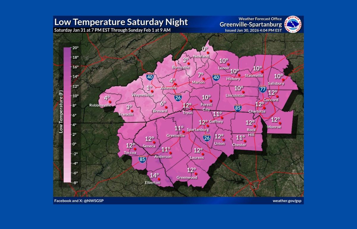
The National Weather Service in Greenville-Spartanburg said a Winter Storm Warning remains in effect through 7 a.m. Sunday for the western Carolinas and northeast Georgia. In addition, an Extreme Cold Warning is in effect through Sunday, with dangerously low wind chills expected.
Wind chills could range from minus 15 to minus 30 degrees in the mountains and as low as minus 5 degrees in lower elevations, according to the weather service. Officials warned that prolonged exposure could lead to hypothermia or frostbite.
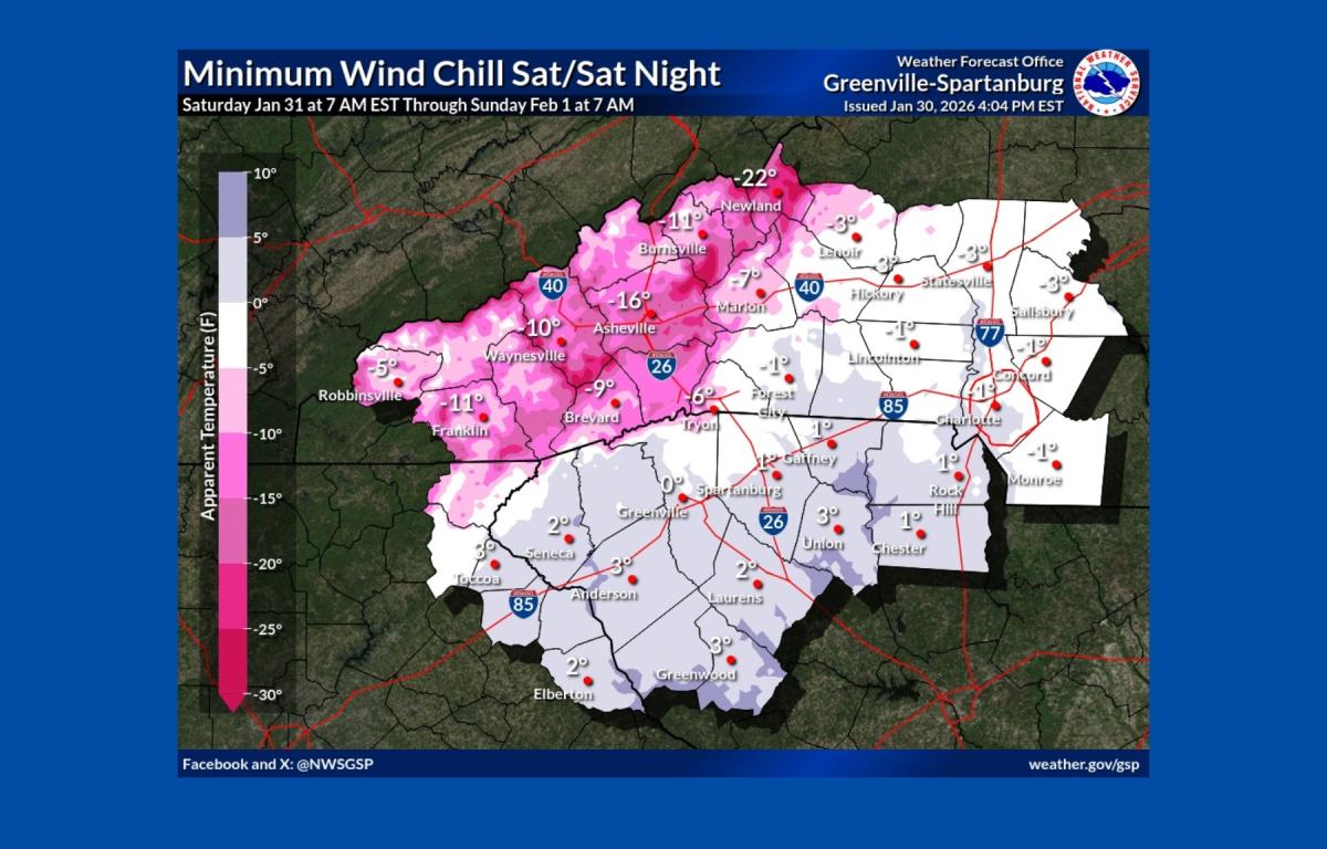
Residents are urged to limit time outdoors, dress in layers including hats and gloves, and check on elderly neighbors and family members. The weather service also advised allowing water pipes to drip to prevent freezing and cautioned against using generators or grills indoors.
Meteorologists said snowfall totals could exceed earlier forecasts in some areas. Local meteorologist Hunter Ward said short-range models suggest the potential for widespread accumulations of 8 inches or more across parts of Western North Carolina, with locally higher totals possible, including in the Asheville area.
Forecasters said travel conditions are expected to remain hazardous through the weekend due to snow-covered roads, gusty winds and extreme cold. Temperatures are expected to gradually warm early next week, with dry conditions returning before another chance of precipitation midweek.