ASHEVILLE, N.C. (828newsNOW) — If your Memorial Day weekend plans include cookouts, campgrounds or time on the lake, keep the umbrella close.
Forecasters say several rounds of rain and thunderstorms are expected across Western North Carolina through Memorial Day, bringing much-needed moisture to drought-stricken areas but also raising concerns about localized flash flooding and a few strong storms.
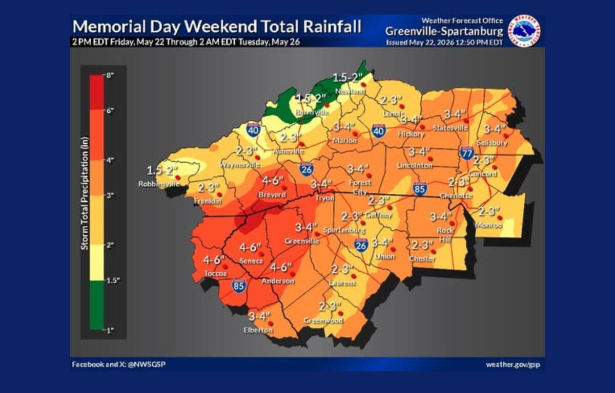
The National Weather Service office in Greenville-Spartanburg said Friday afternoon that most of the rainfall will be beneficial. However, some locations could receive 2 to 3 inches of rain in as little as three hours, creating the potential for isolated flash flooding, especially in the mountains of southwest North Carolina, northeast Georgia and the western Upstate of South Carolina.
“We are concerned about locations receiving 2-3 inches within a three-hour period,” forecasters said, noting that flash flooding cannot be ruled out elsewhere in the region.
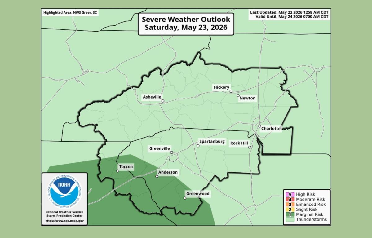
Meteorologists are also watching for a limited risk of severe weather Friday and Saturday afternoons. While the threat remains low, a few storms could produce damaging wind gusts, hail up to an inch in diameter and even a brief, weak tornado.
The weather service urged residents and visitors to remain alert, particularly with thousands expected to attend outdoor events and holiday gatherings across the mountains.
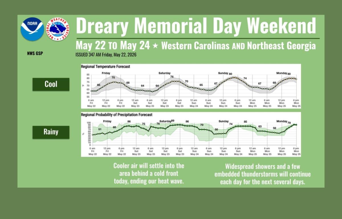
For Asheville, the forecast calls for a soggy stretch beginning Friday night and lasting through Memorial Day.
Rain and thunderstorms are expected overnight, with rainfall totals approaching an inch in some locations. Showers and scattered thunderstorms will continue Saturday, when temperatures are expected to top out in the mid-70s under cloudy skies and occasional fog.
The pattern doesn’t change much Sunday or Memorial Day. Both days carry an 80 percent to 90 percent chance of showers and thunderstorms, with afternoon highs reaching around 80 degrees.
Forecasters say a stubborn weather pattern is responsible for the extended stretch of unsettled conditions. A cool-air wedge east of the mountains is combining with a steady flow of moisture from the Gulf, creating ideal conditions for repeated rounds of rain.
While widespread flooding is not expected, weather officials are keeping a close eye on areas where thunderstorms repeatedly track over the same locations.
Officials are encouraging motorists to use caution during periods of heavy rain and to never drive through flooded roadways.
Looking beyond the holiday weekend, forecasters expect the unsettled pattern to persist into next week. Additional rounds of rain could further reduce drought conditions across the Carolinas, although meteorologists caution that rainfall amounts and impacts remain uncertain several days out.
For now, the message is simple: outdoor plans can continue, but keep an eye on the sky — and the forecast.