ASHEVILLE, N.C. (828newsNOW) — Much of Western North Carolina remains locked in an unusually dry pattern this spring, with drought conditions intensifying across the region and pushing fire danger to elevated levels even as a weekend storm system approaches.
According to drought monitoring data from drought.gov, Buncombe County is fully affected by drought conditions, impacting an estimated 238,000 residents. The county has seen no meaningful change in drought status over the past week or month. Officials report March ranked as the eighth-driest on record in the past 132 years, running 2.62 inches below normal. Year-to-date totals from January through March rank as the sixth-driest on record, with rainfall deficits exceeding 5 inches.
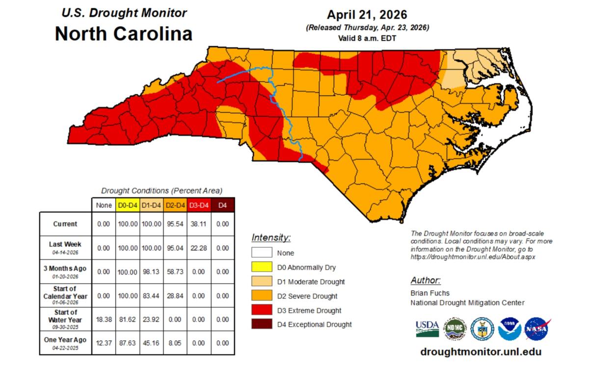
The prolonged dryness has prompted continued wildfire prevention measures across the state. The North Carolina Forest Service says a statewide ban on all open burning remains in effect, citing dry fuels, low humidity and gusty conditions that allow fires to ignite and spread rapidly. Officials are also warning residents to use extreme caution with equipment, vehicles and any activity capable of producing sparks.
“Any fire that develops has the potential to spread quickly,” the National Weather Service in Greenville-Spartanburg said in a Thursday outlook, noting very warm temperatures and critically low afternoon humidity will continue through the end of the week.
Despite the restrictions, fire crews are still responding to active blazes. In Avery County, the Beams Hill brush fire has burned roughly 70 acres and is about 45 percent contained, according to state forest service data. US 19E has reopened, but emergency officials say the situation remains active as ground crews and aircraft continue suppression efforts. A temporary no-fly zone was established over the fire area earlier this week to support water drops and aerial coordination.
![]()
Even so, officials say weather conditions — rather than active fires — remain the primary concern heading into the weekend.
Forecasters expect warm, dry conditions to continue through Friday, with highs near 80 degrees and low humidity keeping fire danger elevated. A wetter pattern is likely to move into the region Saturday and Sunday, bringing showers and possible thunderstorms that could provide needed rainfall.
However, forecasters caution that the improvement may be short-lived. Dry conditions could briefly return early next week as a cold front passes through the region.
Until then, officials say the ongoing drought, dry vegetation and breezy conditions will continue to keep wildfire risk elevated across the mountains and foothills.